Despite living in California for more than two decades, there are a couple of major west coast cities that we hadn't visited before this year: Portland and Seattle. We did pass through Portland (and even had dinner there with friends) on our Oregon trip in 2012, but we didn't see much of the city. And we had never gotten any closer to Seattle than Sea-Tac Airport.
This year, we decided to rectify those omissions, as well as a third one: the fact that we had never been north of the San Francisco Bay area on Amtrak's Coast Starlight. The Los Angeles-Seattle Starlight has long been known as Amtrak's premier long-distance train, both for the beautiful territory it covers and for the quality of its on-board service. We had accumulated enough Amtrak Rewards points to pay for a sleeping car in both directions, so early this year we booked a ten-day trip that would take us to both Seattle and Portland, with a side trip to visit a friend in Coos Bay, Oregon.
We planned our trip for the first half of April. As our departure date of April 6 approached, we began to get nervous watching the weather reports from the Pacific Northwest: rain day after day and week after week. Tom said, "let's wait until May." Marcia said, "what makes you think May will be any better?" So we stuck with our original plans.
April 6 finally came, and we drove 45 minutes from our house to San Luis Obispo, where we boarded the northbound Starlight under a blue California sky.
 One of the train's features is the Pacific Parlour Car, a lounge car available just for sleeping car passengers, and assigned exclusively to the Starlight. We spent many hours here during our trip, watching the scenery from the lounge on the second level of this bi-level car.
 As we left San Luis Obispo we began the long climb up Cuesta Grade, north of town, gaining more than 1,000 feet of elevation in our first 14 miles. A few weeks earlier, these hills had been brown thanks to California's long-running drought. But in March we had a few good soaking rains, and so as we began our journey the hills were covered in many shades of green.
 We reached San Jose shortly after 8:00 P.M., and from that point we traveled through darkness as we stopped at Oakland, Sacramento, Chico and other California cities and towns en route to Oregon and Washington. Our sleeping accommodations consisted of a roomette with two bunk beds. There are larger, more expensive bedrooms on Amtrak overnight trains, but the roomette is a workable alternative for two people.
Marcia took the lower bunk while Tom took the upper, which had very limited clearance between the mattress and the ceiling. Somehow he got in and out of it without injuring himself. With the train's movement and noise, it wasn't a restful night, but we both got a few hours of sleep, and certainly felt better in the morning than if we had spent the night in a coach seat.
Tom was up early, watching the scenery from the lounge car. We were almost into Oregon when 14,179-foot Mount Shasta came into view over a nearby ridge.
 Our first stop in Oregon was Klamath Falls. From there, our route took us over the Cascade Mountains toward Eugene. We had hoped to see more snow in the Cascades, but recent rains followed by some warm days had left just a tiny amount of snow at the highest elevations.
 We traveled through Oregon's pastoral Willamette Valley, under sunny skies, before reaching Portland Union Station in mid-afternoon. This was a major stop for the Starlight, so Tom got off the train and walked around the station, under the sign encouraging travelers to Go By Train.
 Judging by how busy the station was, there did seem to be a lot of people going by train.
 A few minutes after leaving Portland, we crossed the Columbia River, getting a nice view of Mount Hood, which rises to 11,250 feet above sea level. These floating homes are on Hayden Island, between Oregon and Washington.
 We could tell that we were getting close to the end of our journey a few hours later when the twin suspension bridges spanning the Tacoma Narrows came into view. The original bridge at this site opened in July 1940 and collapsed four months later thanks to its inability to withstand the local winds. These two bridges, built in 1950 and 2007, have proved sturdier.
 We could also see 14,411-foot Mount Rainier, 50 miles to the southeast
 We arrived in Seattle about 8:30 P.M., having been on the train for 29 hours since leaving San Luis Obispo. One of the things we most enjoyed about the trip, both coming and going, was meeting new people, particularly at mealtime in the dining car. Tables are set for four, and you never know who will be seated across from you. At different meals we met people from Philadelpha, Seattle, and Germany, as well as a couple, both teachers, from southern California; they had taught in several other countries earlier in their careers. The food in the dining car was surprisingly good, too.
We were surprised at how many families with young children were on the train. But we can certainly understand why they would travel this way, since it's far less stressful than a car trip.
We spent two nights in Seattle, and one of our first priorities was to visit Pike Place Market, which is full of vendors selling a variety of wares, with an emphasis on local foods, flowers and other products...
 ... and, of course, magnificent-looking fish and other seafood. On the day we were there, we saw several signs announcing that the first Alaskan halibut of the season had just arrived.
 We had breakfast at the Crumpet Shop, a bakery near the market that specializes in its namesake product, and then spent more than an hour touring the market itself.
When we began to plan our trip, Marcia got in touch with her friend Liz, who we had gotten to know during our 2008 summer at Grand Teton National Park. Liz and Marcia worked together in the gift shop at Jackson Lake Lodge that summer, and though she's a generation younger than we are, she and Marcia had become close over those four months.
Liz grew up in Seattle, and is a big booster of her home town. When she learned that we would be visiting the city, she suggested that we contact her mother, Rayma, to see if she would be available to give us a tour. Rayma, it turned out, was not just available, she was willing, even enthusiastic, and she turned out to be a wonderful tour guide. She picked us up at our hotel and spent the next several hours driving us from one end of Seattle to the other, providing excellent narration along the way.
Among the more memorable stops were:
• The North Admiral neighborhood of West Seattle, where we had an excellent view of downtown Seattle, including the Space Needle and the Bainbridge Island ferry (which is something we'll take advantage of the next time we're in Seattle).

• The Volunteer Park Conservatory...


• The Ballard Locks Fish Ladder. The Seattle area has a complex network of lakes and waterways, both freshwater and saltwater. One of the freshwater lakes is Lake Union, which lies north of downtown Seattle and south of the University of Washington. It is home to a variety of maritime enterprises, as well as two seaplane bases and a number of floating homes.
The Hiram M. Chittenden Locks, known locally as the Ballard Locks, are the gateway between the Lake Washington Ship Canal and Lake Union to the east, and Puget Sound to the west. Because of the 20-foot difference in elevation between Lake Union and the sound, the Locks are used to raise eastbound vessels and lower those headed west. This is the spillway where fresh water from Lake Union pours into Puget Sound.
 To allow salmon to return to Lake Union to spawn at the end of their life cycle, a fish ladder lets the fish get around the locks and dam en route to fresh water. On the day we visited, the fish ladder was not in heavy use, but it does provide a critical link in helping to maintain the salmon population.

 As we ate, we had a view of the small boat harbor adjacent to the restaurant. It was an authentically Pacific Northwest meal with great company.
It rained on and off during the last couple of hours of our Seattle tour, but that was the first and last rain we would see during our ten-day trip. Despite the wet weather that the region had endured for many weeks leading up to our trip, the weather gods smiled on us for 99 per cent of the time that we were in Washington and Oregon. We were very grateful.
Our stay in Seattle was short -- one full day, and part of the next morning before we boarded a train for Portland. George suggested that one thing we might want to see before we left town was Benaroya Hall, home to the Seattle Symphony. It is home to two huge chandeliers created by glass artist Dale Chihuly. They were magnificent.
 Amtrak serves Seattle through King Street Station, built in 1906 and restored over the past four years. Waiting for our train here was much more pleasant than any airport.
 The station is a local landmark thanks to its 242-foot tower, modeled after the Campanile di San Marco in Venice.
 Our train, like the one above, was part of Amtrak's Cascades service, using low-slung, European-style cars designed by a Spanish company. We reached speeds as high as 79 mph when we were moving, but heavy freight traffic meant we also spent a lot of time sitting. Still, it was a pleasant ride, and we arrived in Portland close to our scheduled mid-afternoon arrival time.
We rented a car and drove to our hotel in suburban Beaverton. The next morning, we connected with our friend Margie, who had been one of Marcia's college roommates. She and her husband Ken had migrated from New Jersey to Portland a few years ago. They liked it but still felt the pull of the east coast, where their son and daughter live. But after a one-year return to the east, they decided that they really were westerners, so earlier this year they moved back to Portland, where they plan to buy a house. Ken wasn't able to join us, but Margie spent the entire day guiding us around downtown Portland.
We started with a light rail ride from Hillsboro into the city. Portland has been the leader among U.S. cities in making investments over the past 30 years in light rail systems designed to get people out of their cars. The MAX system now has four lines totalling 53 miles, reaching from the center city into the most heavily populated suburbs, including a line to the Portland airport.
Augmenting the MAX system are a couple of streetcar lines within downtown Portland, like the one below. The sign in the distance reads "Go By Streetcar," and many Portlandians do exactly that.
 Our good luck with the weather continued, and we walked from one end of downtown Portland to the other, in addition to a couple of streetcar and MAX rides to go longer distances. One of our first destinations was Powell's, which was the largest bookstore we had ever been in.
 After a coffee-and-pastries stop on the north side of downtown, we boarded a MAX train to get to the Portland Aerial Tram. Its mission is to serve the Oregon Health and Science University hospital complex, which is on a hill overlooking downtown Portland and the Willamette River.
 The tram's web site is gobytram.com. At the lower tram station is a "bike valet," promoting itself with the slogan "Go By Bike." On its web site, its owner says his belief is that "to make the world a better place it is going to require a lot more people riding bicycles."
 So, in Portland you're encouraged to go by train, streetcar, tram or
bike. We didn't see any signs encouraging us to go by car.
So, in Portland you're encouraged to go by train, streetcar, tram or
bike. We didn't see any signs encouraging us to go by car.
Aside from serving the OSHU community, the tram is a tourist attraction. From the upper station you get views of Mount Hood...
 ... as well as the city and, in the distance, Mount St. Helens.
 After we returned to the lower station, we took a long walk along the Waterfront Park Trail, followed by dinner at a local brewpub. By then it was time for us to get back on the MAX train and return to Hillsboro, near our hotel. It had been a pleasant and informative day; we felt as though we had learned a lot about Portland. Thank you, Margie!
 The next day, we headed our rental car south through the Willamette Valley toward Eugene, where we would spend the night before continuing on to Coos Bay. The valley is dotted with wineries, but we wanted to get close to Eugene before stopping at any. Our friend Tom Foster in Coos Bay suggested that we stop at Silvan Ridge Winery, just outside Eugene, and it was perfect. It's in a beautiful setting, and we enjoyed the wine and hospitality in the tasting room before continuing on to Eugene for the night.
 The following morning, we completed our trip to Coos Bay, a couple of hours from Eugene. Our friend Tom has been in Coos Bay for close to three years, helping to restart service on a 134-mile rail line that had been dormant for several years. We had seen him during our 2012 trip, and enjoyed our visit so much that we wanted to get back there before he decides to move on to other endeavors.
 This is a view of one of the railroad's many bridges, between Coos Bay and Florence. The scenery is breathtaking, but great scenery often makes for challenging railroading. The many rivers and creeks that the Coos Bay Rail Link has to span, the heavily forested area it traverses, and the region's wet winters combine to require constant vigilance by train crews as well as a high budget for maintenance.
 Like the railroad, the area's highways have to contend with nature's obstacles. For U.S. Highway 101, which runs the length of the Oregon coastline, that means many bridges like the one below over the Siuslaw River. Fortunately this one, like several others along the state's coast, was built during the Great Depression when Art Deco was in vogue.
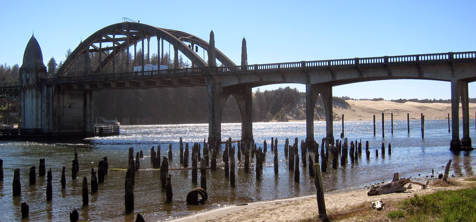 As we knew we would, we had a fun weekend visiting Tom, but on Monday morning it was time to leave Coos Bay. We drove back to Eugene, where we boarded the southbound Coast Starlight to return to California. Thanks to the hospitality of all of our hosts, and to our good luck with the weather, we had had a memorable ten days. And the next time we visit Portland or Seattle, we'll have a list of things to do that we missed during our short visits on this trip.

This year, we decided to rectify those omissions, as well as a third one: the fact that we had never been north of the San Francisco Bay area on Amtrak's Coast Starlight. The Los Angeles-Seattle Starlight has long been known as Amtrak's premier long-distance train, both for the beautiful territory it covers and for the quality of its on-board service. We had accumulated enough Amtrak Rewards points to pay for a sleeping car in both directions, so early this year we booked a ten-day trip that would take us to both Seattle and Portland, with a side trip to visit a friend in Coos Bay, Oregon.
We planned our trip for the first half of April. As our departure date of April 6 approached, we began to get nervous watching the weather reports from the Pacific Northwest: rain day after day and week after week. Tom said, "let's wait until May." Marcia said, "what makes you think May will be any better?" So we stuck with our original plans.
April 6 finally came, and we drove 45 minutes from our house to San Luis Obispo, where we boarded the northbound Starlight under a blue California sky.
Marcia took the lower bunk while Tom took the upper, which had very limited clearance between the mattress and the ceiling. Somehow he got in and out of it without injuring himself. With the train's movement and noise, it wasn't a restful night, but we both got a few hours of sleep, and certainly felt better in the morning than if we had spent the night in a coach seat.
Tom was up early, watching the scenery from the lounge car. We were almost into Oregon when 14,179-foot Mount Shasta came into view over a nearby ridge.
We were surprised at how many families with young children were on the train. But we can certainly understand why they would travel this way, since it's far less stressful than a car trip.
We spent two nights in Seattle, and one of our first priorities was to visit Pike Place Market, which is full of vendors selling a variety of wares, with an emphasis on local foods, flowers and other products...
When we began to plan our trip, Marcia got in touch with her friend Liz, who we had gotten to know during our 2008 summer at Grand Teton National Park. Liz and Marcia worked together in the gift shop at Jackson Lake Lodge that summer, and though she's a generation younger than we are, she and Marcia had become close over those four months.
Liz grew up in Seattle, and is a big booster of her home town. When she learned that we would be visiting the city, she suggested that we contact her mother, Rayma, to see if she would be available to give us a tour. Rayma, it turned out, was not just available, she was willing, even enthusiastic, and she turned out to be a wonderful tour guide. She picked us up at our hotel and spent the next several hours driving us from one end of Seattle to the other, providing excellent narration along the way.
Among the more memorable stops were:
• The North Admiral neighborhood of West Seattle, where we had an excellent view of downtown Seattle, including the Space Needle and the Bainbridge Island ferry (which is something we'll take advantage of the next time we're in Seattle).
• The Volunteer Park Conservatory...
... a Victorian-style greenhouse in the Capitol Hill neighborhood with thousands of plant specimens, with an emphasis on palms, ferns, cacti and bromeliads (members of the pineapple family). Some of the specimens change with the seasons, while others remain in place year-round.
On the day we were there, it seemed that the most common color on display was pink.
• The Ballard Locks Fish Ladder. The Seattle area has a complex network of lakes and waterways, both freshwater and saltwater. One of the freshwater lakes is Lake Union, which lies north of downtown Seattle and south of the University of Washington. It is home to a variety of maritime enterprises, as well as two seaplane bases and a number of floating homes.
The Hiram M. Chittenden Locks, known locally as the Ballard Locks, are the gateway between the Lake Washington Ship Canal and Lake Union to the east, and Puget Sound to the west. Because of the 20-foot difference in elevation between Lake Union and the sound, the Locks are used to raise eastbound vessels and lower those headed west. This is the spillway where fresh water from Lake Union pours into Puget Sound.
And speaking of salmon, we enjoyed dinner a short distance from the Ballard Locks, at Chinook's restaurant (Chinook is the formal name for king salmon). Rayma's husband (and Liz's Dad), George, joined us for an excellent seafood dinner. Marcia went for the newly arrived Alaskan halibut and Tom chose the silver (coho) salmon.
It rained on and off during the last couple of hours of our Seattle tour, but that was the first and last rain we would see during our ten-day trip. Despite the wet weather that the region had endured for many weeks leading up to our trip, the weather gods smiled on us for 99 per cent of the time that we were in Washington and Oregon. We were very grateful.
Our stay in Seattle was short -- one full day, and part of the next morning before we boarded a train for Portland. George suggested that one thing we might want to see before we left town was Benaroya Hall, home to the Seattle Symphony. It is home to two huge chandeliers created by glass artist Dale Chihuly. They were magnificent.

We rented a car and drove to our hotel in suburban Beaverton. The next morning, we connected with our friend Margie, who had been one of Marcia's college roommates. She and her husband Ken had migrated from New Jersey to Portland a few years ago. They liked it but still felt the pull of the east coast, where their son and daughter live. But after a one-year return to the east, they decided that they really were westerners, so earlier this year they moved back to Portland, where they plan to buy a house. Ken wasn't able to join us, but Margie spent the entire day guiding us around downtown Portland.
We started with a light rail ride from Hillsboro into the city. Portland has been the leader among U.S. cities in making investments over the past 30 years in light rail systems designed to get people out of their cars. The MAX system now has four lines totalling 53 miles, reaching from the center city into the most heavily populated suburbs, including a line to the Portland airport.
Augmenting the MAX system are a couple of streetcar lines within downtown Portland, like the one below. The sign in the distance reads "Go By Streetcar," and many Portlandians do exactly that.
Aside from serving the OSHU community, the tram is a tourist attraction. From the upper station you get views of Mount Hood...
We spent the
weekend with Tom, and on the second day we visited the historic town of
Florence, whose boat harbor was full of both pleasure craft and working
vessels.


