We have lived in California for more than 20 years, but prior to this trip we had spent very little time in nearby Oregon. A few months ago we decided that this would be our year to visit the state, mainly because we have friends currently living in both Coos Bay and Portland.
 We had pleasant visits at a couple of wineries, one in the Carneros
region and one in the Napa Valley, and left the area with an ample supply of
wine for our trip. This scene is near Kenwood in the Sonoma Valley (a.k.a. the Valley of the Moon), where many of the hillsides are covered with vines, as is most of the valley floor.
We had pleasant visits at a couple of wineries, one in the Carneros
region and one in the Napa Valley, and left the area with an ample supply of
wine for our trip. This scene is near Kenwood in the Sonoma Valley (a.k.a. the Valley of the Moon), where many of the hillsides are covered with vines, as is most of the valley floor.
 Heading north, we joined coastal Highway 1 at Jenner, near the mouth of the Russian River, where the marine layer was doing its best to move inland. But as we drove along the Sonoma coast, we had a bright sunny afternoon, and the fog stayed just off shore.
 Our destination for that night was St. Orres, a rustic lodging place on Highway 1 in Gualala, in the southwest corner of Mendocino County. This part of the California coast was once occupied by Russia, and the architecture at St. Orres reflects this heritage.
 St. Orres has a few rooms in the main lodge, but we stayed in one of several cabins on the property. In fact, we were able to reserve the same cabin (Sorrel Glen, located on the edge of a large grove of redwood trees) where had stayed on our first visit several years ago.
 After an excellent dinner in the St. Orres dining room we settled down in our cabin, feeling far from civilization. In the morning, breakfast (a rice pudding custard
wedge, fruit, gingerbread, homemade granola and juice) was delivered to us in a large wooden box, and we enjoyed eating on the rear deck of our cabin, with the redwoods towering above us.
After an excellent dinner in the St. Orres dining room we settled down in our cabin, feeling far from civilization. In the morning, breakfast (a rice pudding custard
wedge, fruit, gingerbread, homemade granola and juice) was delivered to us in a large wooden box, and we enjoyed eating on the rear deck of our cabin, with the redwoods towering above us.
 From Gualala, we drove north through Mendocino and Fort Bragg, passing many scenic spots like this one near Port Arena.
 About 25 miles north of Fort Bragg, Highway 1 leaves the coast and turns inland, where it becomes a winding, up-and-down road with many sharp turns. For several miles we followed a driver who was apparently unnerved by the many transitions and adjustments he had to make (our guess was that he may have been one of the many overseas visitors we noticed during our trip). Once we got past him, we made better progress and finally reached the north end of Highway 1, at a junction with U.S. 101.
Our destination for this night was Ferndale, California, a quaint Humboldt County town with a population of just over 1,000, several miles off Highway 101. It is full of Victorian homes and commercial buildings, and we stayed in one of them, aptly named the Victorian Inn. The town had been severely damaged in a magnitude 7.2 earthquake in 1992, causing more than $10 million in damage in Ferndale alone, but twenty years later the town seems to have fully recovered.

 But the real showpiece in town was a B & B, the Gingerbread Mansion, which was nearing the end of a top-to-bottom renovation. A sign on the door said that it would reopen on July 1, although we were there in mid-July and it appeared that construction workers were not quite done.
 Aside from Victorian buildings, one of Ferndale's tourist attractions is its cemetery. According to a sign, the site was chosen because its terrain made it unsuitable for commercial or farming purposes. There are numerous family burial plots, and the graves continue up the hillside.
 One of the headstones provided a reminder of the perils of travel in the nineteenth century (Boland was a passenger on the ill-fated steamer Chilkat).
 On our way to Ferndale, we started our exploration of the north coast redwoods with the Avenue of the Giants, a 31-mile road that connects with Highway 101 at both ends but offers a slower route through Humboldt Redwoods State Park. We made several stops to admire these magnificent trees, which are striking not just because of their size (the park has many trees greater than 350 feet in height) and age (many are estimated to be more than 1,000 years old) but also because they seem to grow so close to each other. Although we had seen coastal redwoods before, these seemed even more impressive. We watched in amazement as the distant tops of some of the trees swayed in the breeze.
 The next day, we drove past the town of Eureka and into Redwood National Park, which binds together three smaller state parks, all of them home to large redwood groves. Near the south end of the park, we drove up a long hill to the Lady Bird Johnson Grove, site of a popular loop trail.
 The grove's 1,200-foot elevation put it into the cloud cover, and after a short walk through the fog we decided to see what other trails might be available at a lower elevation. But we were impressed with the lush vegetation in this area, and particularly with the heavy layer of moss that covered trees both living and dead.
 At the Big Tree wayside in Prairie Creek Redwoods State Park we found a circle trail that gave us some nice views of the redwoods...
 ... as well as the lush forest floor.
 It's been estimated that the old-growth California redwoods still in existence represent only about five per cent of the trees that were alive in the mid-nineteenth century. Still, while the loss to logging and other human activities has been staggering, we can be grateful to have these few majestic groves still in existence. "Awesome" is an overused word, but an appropriate one for these magnificent trees.
After spending the better part of two days seeing the redwoods, we were within 40 miles of the Oregon state line. We had tried to get a reservation for the night at the Requa Inn, a historic property on the banks of the Klamath River, but they were full so we stayed at a nearby motel.
 However, we were able to eat dinner at the Requa that night, and it was a
memorable experience. They have one communal seating for dinner, and the menu
consists of whatever fresh ingredients the inn's two chefs have been able to
obtain that day. One of the chefs comes to the table before each course to describe it and answer any questions, and then both chefs act as servers.
However, we were able to eat dinner at the Requa that night, and it was a
memorable experience. They have one communal seating for dinner, and the menu
consists of whatever fresh ingredients the inn's two chefs have been able to
obtain that day. One of the chefs comes to the table before each course to describe it and answer any questions, and then both chefs act as servers.
We had four courses, some plated, some serve-yourself and some multi-part. We started with spinach soup and ended with a dessert plate of homemade strawberry sorbet with fried basil and sugar, a soft meringue brick and olive oil sponge cake. In between we enjoyed broth with clams, baby new potatoes and carrots, and a main course of tuna fillet, accompanied by smelts, fried bread and summer squash salad. Everything was delicious and beautifully presented.
The next day, we started our drive up the Oregon coast. In some places, U.S. 101 hugs the coast, while in others it's located farther inland. Today as every day in our coastal drive, we had several stops for construction. Highway 101 is constantly under attack from nature as it erodes along the edges or develops bumps or depressions depending on the base below the surface. In one area, the placement of the highway was being moved inland because the ground under the road was crumbling into the Pacific.
After passing through the town of Brookings, we got some great views of the coastline, like this one at the Arch Rock turnout, part of the Samuel H. Boardman State Scenic Corridor.
 At Cape Sebastian State Park, where the wind seemed to be blowing in excess of 40 miles per hour, we stopped for the excellent views both northward...
 ... and southward.
 The most striking difference between the Oregon Coast and the coastline we are more familiar with in California is that Oregon's is simply much greener. In California, where there is vegetation, much of it is brown (or golden, as the state's publicists would call it) during the summer. Not so in Oregon!
We took some time to tour the lighthouse at Cape Blanco, which once claimed the title of the westernmost point in the lower 48. That title has been challenged on behalf of a couple of points in Washington State, but in any case we knew that we were as far west as we would get on this trip.
 The lighthouse was built in 1870 and like all light stations of that era, was manned by a keeper who was responsible for keeping the light burning and for daily cleaning of the lens. In addition, as this sign notes, the remoteness of the location meant that the keeper had to supply his or her own food (yes, Cape Blanco did have a female keeper early in twentieth century). The light was electrified in 1936 and automated in 1980, and remains in service today.
 The French-built lens in the Cape Blanco lighthouse (installed in 1936) measures 4’8" in diameter and 6’8" in height.
 At the end of our first week on the road, we arrived in Coos Bay, Oregon, where our longtime friend Tom Foster is serving as general manager of Coos Bay Rail Link. The 137-mile rail line between Coos Bay and Eugene was opened in 1916 by Southern Pacific Railroad and closed in 2007 by its then-owner, RailAmerica, Inc. The Port of Coos Bay has since acquired the line and is working to revive rail service. Tom took us for a hi-rail ride over the southern portion of the line, as far as the town of Reedsport, where we had a lunch at a waterside café with a view of the railroad's bridge over the Umpqua River.
 That evening, Tom invited us to a fund-raising dinner at the Coos Art Museum, where we enjoyed talking with supporters of the local arts community and viewing the maritime art on exhibit.
The next day, we visited Shore Acres State Park, west of Coos Bay, which offered a dramatic perspective on the geography of the coast...
 ... as well as acres of beautiful gardens...
 ... including an All-America rose garden, featuring many gorgeous varieties.
 From Shore Acres, we drove a short distance to Cape Arago State Park for more great coastal views.
 Along the way, we stopped at a turnout where a group of volunteer
naturalists had set up scopes to view the islands just offshore,
allowing us to view a variety of marine mammals (harbor seals, elephants
seals, California sea lions, and Steller sea lions) hauling themselves
out of the water and sunning themselves on the small island beaches. On
the way back, we stopped for lunch (excellent crab cakes, and tuna and chips) in the fishing community of
Charleston.
Along the way, we stopped at a turnout where a group of volunteer
naturalists had set up scopes to view the islands just offshore,
allowing us to view a variety of marine mammals (harbor seals, elephants
seals, California sea lions, and Steller sea lions) hauling themselves
out of the water and sunning themselves on the small island beaches. On
the way back, we stopped for lunch (excellent crab cakes, and tuna and chips) in the fishing community of
Charleston.
From our arrival on Friday evening to our departure on Monday morning, we had a great time visiting with Tom and getting acquainted with the area around Coos Bay.
After leaving Coos Bay, we continued north on U.S. 101, much of which was inland from the ocean. But we did reach the coast at Newport, which like many of the state's larger coastal communities, was built at a point where a river (in this case, the Yaquina) empties into the Pacific. And like other such towns along the Oregon coast, there is a large bridge carrying Highway 101 over the water.
 Newport grew up as a fishing community, and while today tourism is an important part of the local economy, the two are very much interrelated, as the signs on this building suggest.
 North of Newport, we stopped near Otter Rock, where we encountered the only surfing beach of our Oregon trip. We imagine that the water was quite cold, but of course all the surfers wore body suits to protect themselves.
 Our destination that evening was the town of Garibaldi, on Tillamook Bay. Its port is home to many commercial and sport fishing vessels. Marcia wanted to stop at the local cannery to pick up some tuna, and while she was there she bought some fresh local shrimp, which we used as the main course for that night's dinner in our hotel room.


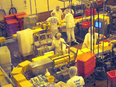
 Part of the attraction is the viewing area where you can see large blocks of cheese entering on a conveyor, being cut into one-, two- and three-pound loaves, and then wrapped and packaged for distribution. You can also sample several varieties of Tillamook cheese.
 But we think the real attraction is the ice cream counter, where you can purchase cones or dishes of any one (or more) of Tillamook's 30 flavors of ice cream. And high quality ice cream it is! We understand that the other home-grown brand of Oregon ice cream (Umpqua) has its fans, but we were more than pleased with our samples of Tillamook. We had never tried this brand before, but now it's one of our favorites.
Our next destination was Beaverton, just outside Portland. On our way into the Portland area we stopped at a couple of wineries, including Shafer Vineyard Cellars, which has been in operation since 1978 (a long time by the standards of Oregon wineries). The co-owner, Miki, gave us a warm reception in the tasting room, and we enjoyed the great view across the vineyards toward the neighboring hills.
 We were headed for Beaverton to visit our friends Margie and Ken. Margie was one of Marcia's roommates at Bates College in Maine, and Margie and Ken spent their working and family-raising years in New Jersey. Four years ago they drove their van west in search of adventure and a new environment. They ended up in Portland, at least for a while. We saw them briefly in California last year (for the first time in almost 30 years!) and decided then that we would try to visit them before they left Oregon.
Margie and Ken are active outdoors people. They've spent much of their time in Oregon working with the local Habitat for Humanity group, building and remodeling houses for people who otherwise couldn't afford them. They've also spent a lot of time hiking and exploring the local landscape, and they suggested that we spend a day with them taking a look at the Columbia River Gorge. That sounded good to us, so we set out across Portland and soon were on Interstate 84 entering the gorge.
Our first stop was at Multnomah Falls, whose 600-foot-plus total height makes it one of the tallest waterfalls in the United States (its exact rank is a matter of some debate). Regardless of exact height or rank it is a beautiful location. On Margie's and Ken's advice, we got an early start, because this is an extremely popular attraction and gets very crowded from mid-morning on. We did beat most of the crowd, and from the base of the falls we walked up a trail that took us close to the top.
 The base of the main falls is a misty place, as the water splashes into a large pool. We were very glad to have a chance to spend some time here before it got crowded.
 And, there was one added treat (for Tom, at least): frequent Union Pacific trains passing within sight of the falls.
 After a picnic lunch near Cascade Locks, a few miles upriver, we spent some time visiting another major attraction, the Bonneville Lock and Dam. This is the dam's spillway, which controls the flow of water into the lower Columbia River; the land in the background is in the state of Washington.
 Bonneville Lock and Dam was built in the 1930s, primarily as a way of producing inexpensive hydroelectric power for the northwest. It continues to do so today through two powerhouses: this one, on the Oregon side of the river, and a second one on the Washington side.
 In the building and operation of this complex, much attention was given to the migration of fish upriver for spawning. A fish ladder – in effect, an elaborate stairway – was created that allows salmon and steelhead to move upstream, and employees are assigned to a fish viewing area to provide a daily count of fish moving up the ladder and assure that healthy populations are maintained.
After we left Bonneville we drove to Crown Point, overlooking the Gorge. This is the view upriver; Washington is on the left and Oregon on the right.
 While we were in Portland, we also had a chance to visit our friend Liz from our 2008 summer in Grand Teton National Park. The four of us met Liz for dinner at McMenamins Kennedy School, a former elementary school that has been turned into a restaurant/pub/event venue with a unique character. (The McMenamin brothers have also taken other historic buildings in Oregon and Washington and given them new life as eating, drinking and lodging establishments.) Dinner was a lot of fun, both because of the setting and because we were able to renew acquaintance with Liz.
And we want to thank our friends Margie and Ken for being such gracious hosts and introducing us to the Portland area. (Note to Margie and Ken: we're eager to find out where you land next, so we can visit you there, too!)
We left Portland by again traveling through the Columbia River Gorge as far as Hood River, where we turned south toward Mount Hood. We stopped at the Mt. Hood Winery to taste their wines, and from their front door we had this wonderful view of the mountain.
 We stayed in Bend, Oregon, that night. It’s a very appealing city
with lovely green parks, nice cafés, shops and activities, and while we didn't have time to enjoy much of what the city had to offer, we liked it enough to put it on our return-visit list for our next trip to Oregon.
We stayed in Bend, Oregon, that night. It’s a very appealing city
with lovely green parks, nice cafés, shops and activities, and while we didn't have time to enjoy much of what the city had to offer, we liked it enough to put it on our return-visit list for our next trip to Oregon.
From Bend, we headed south toward Crater Lake, passing through miles and miles of forests. More than half of Oregon is government land of various categories. The U.S. Forest Service and the Bureau of Land Management each control about one quarter of the state's land, with the remaining public land falling into a variety of categories: National Parks and Monuments, Wilderness Areas, Wildlife Refuges, State Parks and Forests, and other designations.
On the way to Crater Lake we had light rain with dark clouds overhead; it looked ominous. We decided to drive around the lake on the Rim Drive, going in a clockwise direction starting in the northwest. Our first stop was disappointing because the lake's color was closer to slate than the vivid blue we had expected. However, within 15 minutes, the clouds had dispersed and at our next viewpoint the lake was as beautiful as advertised.
 Crater Lake is actually a volcanic crater (and in fact, this is technically still an active volcano). About 7,700 years ago, there was a violent eruption here, after which the volcano's magma chamber emptied. This caused the volcano's peak to collapse, forming a deep caldera. The resulting basin filled with water over time, and today the lake's deepest point is 1,943 feet under the surface of the water.
We continued our drive toward the Rim Village, where Crater Lake Lodge and other visitor facilities are located, making many stops along the way to get different perspectives on the lake.
 At the village, we walked to an overlook that had a display with many helpful signs, like this one:
 Looking down from the overlook, we could see some of that "unabsorbed green sunlight" being reflected at us from the water's edge.
 We went into the lodge for lunch, which Marcia described in her travel diary as a typical “national park lodge restaurant” meal – good but not
noteworthy. Still, it was fun to soak up the atmosphere of this 97-year old lodge.
We went into the lodge for lunch, which Marcia described in her travel diary as a typical “national park lodge restaurant” meal – good but not
noteworthy. Still, it was fun to soak up the atmosphere of this 97-year old lodge.
 There's more to Crater Lake National Park than the lake and the lodge, though. After lunch we stopped at the visitor center near the park's headquarters and then took a couple of nature walks, including one on the Castle Crest wildflower trail, where we were rewarded with a colorful variety of flowers in bloom.


 Our stop that night was near Medford, in the town of Central Point. Prior to this trip, we couldn't have found Central Point on a map, but now we know that it is a small hub of gourmet delights, including a very good cheesemaker (Rogue Creamery), which happens to be just a few steps from a high-end chocolatier (Lillie Belle Farms). And to get from the cheese store to the chocolate shop you have to pass the Taste of Alaska food truck and the Ledger David wine tasting room.
But this part of Oregon is full of other interesting places to explore, too. For starters, Central Point is only a 25-minute drive from Ashland, site of the famous Oregon Shakespeare Festival. Ashland is also home to Southern Oregon University and to numerous shops, restaurants, and a terrific Saturday market, the Rogue Valley Growers and Crafters Market, which happened to coincide with our short visit there.
 Nearby is another interesting though much smaller town, Jacksonville. It had begun as a mining camp in the 1850s and flourished over the next few decades but then waned in importance when the railroad bypassed the town in favor of Medford. That left the town somewhat frozen in time, so today it has a number of well-preserved nineteenth-century buildings lining its main street.
We had passed through here in 2008 but didn't have time to stop. This time, we did spend a while exploring the town, and had a very good lunch at the Jacksonville Inn, which was built in 1861.
 A few minutes away, we found the last Oregon winery we would visit on this trip, Caprice Vineyards.
 We were attracted in part by the fact that Caprice billed itself not just as a winery, but also as an alpaca farm. The tasting room was full of alpaca products, and for ten dollars Marcia bought a large plastic bag of recently-shorn alpaca fleece. Outside, she found the animals that had sacrificed this fiber for her benefit.
 When they were shorn, the hair on their heads was left untouched, giving them a punk look.
 Later that afternoon, we returned to California along Interstate 5. Near the town of Yreka, 14,179-foot Mount Shasta, whose last eruption was in 1786, came into view.
 By the time we returned to our home in Santa Maria, our little Honda Fit had recorded 2,380 miles over 16 days (and to its credit, averaged 41 miles per gallon, despite all the mountain roads it had to overcome in the course of this trip).
 If you've read this far, you know that we had a great time exploring Oregon and northern California, and we found many reasons to make a return visit in the future.
We want to thank our friend Sarah (a colleague from our 2008 summer at Grand Teton) and her husband Tim, whose blog reports about their recent cross-country trip were very helpful to us in planning our trip.
And of course we thank our friends Tom, Margie and Ken for the hospitality they provided us, and for helping make this such a memorable trip!
Text and images ©2012 Tom and Marcia Murray
Our itinerary would take us first to the San Francisco area, where our daughter Lindy lives; through the Napa and Sonoma wine country; into the redwood country of northern California and then on to southeastern Oregon for a weekend stop at Coos Bay; and, after a drive further north along the Oregon coast, eastward across the Coast Range and into the Portland area. We would return to California by way of central Oregon (with a stop at Crater Lake National Park). We set aside two weeks for the trip, trying to schedule enough time to see the sights along the way without feeling pressured into driving too far each day.
After visiting Lindy in Walnut Creek, we headed north through wine country. We spent one night in Napa, and while the travel booker (Tom) claims it was just coincidence, we did end up in a Marriott property on the route of the Napa Valley Wine Train.
(Click on any photo to enlarge. All photos © 2012 Tom Murray)


Our destination for this night was Ferndale, California, a quaint Humboldt County town with a population of just over 1,000, several miles off Highway 101. It is full of Victorian homes and commercial buildings, and we stayed in one of them, aptly named the Victorian Inn. The town had been severely damaged in a magnitude 7.2 earthquake in 1992, causing more than $10 million in damage in Ferndale alone, but twenty years later the town seems to have fully recovered.

In fact, we were quite impressed with the condition of most of the town's older homes. The one below was typical, with fresh paint all around and a nicely maintained garden.


After spending the better part of two days seeing the redwoods, we were within 40 miles of the Oregon state line. We had tried to get a reservation for the night at the Requa Inn, a historic property on the banks of the Klamath River, but they were full so we stayed at a nearby motel.

We had four courses, some plated, some serve-yourself and some multi-part. We started with spinach soup and ended with a dessert plate of homemade strawberry sorbet with fried basil and sugar, a soft meringue brick and olive oil sponge cake. In between we enjoyed broth with clams, baby new potatoes and carrots, and a main course of tuna fillet, accompanied by smelts, fried bread and summer squash salad. Everything was delicious and beautifully presented.
The next day, we started our drive up the Oregon coast. In some places, U.S. 101 hugs the coast, while in others it's located farther inland. Today as every day in our coastal drive, we had several stops for construction. Highway 101 is constantly under attack from nature as it erodes along the edges or develops bumps or depressions depending on the base below the surface. In one area, the placement of the highway was being moved inland because the ground under the road was crumbling into the Pacific.
After passing through the town of Brookings, we got some great views of the coastline, like this one at the Arch Rock turnout, part of the Samuel H. Boardman State Scenic Corridor.


We took some time to tour the lighthouse at Cape Blanco, which once claimed the title of the westernmost point in the lower 48. That title has been challenged on behalf of a couple of points in Washington State, but in any case we knew that we were as far west as we would get on this trip.


The next day, we visited Shore Acres State Park, west of Coos Bay, which offered a dramatic perspective on the geography of the coast...


From our arrival on Friday evening to our departure on Monday morning, we had a great time visiting with Tom and getting acquainted with the area around Coos Bay.
After leaving Coos Bay, we continued north on U.S. 101, much of which was inland from the ocean. But we did reach the coast at Newport, which like many of the state's larger coastal communities, was built at a point where a river (in this case, the Yaquina) empties into the Pacific. And like other such towns along the Oregon coast, there is a large bridge carrying Highway 101 over the water.


Garibaldi is also home to the Oregon Coast Scenic Railroad, and while we didn't take a train ride, we did make a quick photo stop on our way out of town.

Our route in and out of Garibaldi took us past the Tillamook Cheese factory, and so we had to stop once in each direction. This is a Disney-class tourist attraction in this part of Oregon. The parking lot was full of cars, RVs and buses from many states.


Our next destination was Beaverton, just outside Portland. On our way into the Portland area we stopped at a couple of wineries, including Shafer Vineyard Cellars, which has been in operation since 1978 (a long time by the standards of Oregon wineries). The co-owner, Miki, gave us a warm reception in the tasting room, and we enjoyed the great view across the vineyards toward the neighboring hills.

Margie and Ken are active outdoors people. They've spent much of their time in Oregon working with the local Habitat for Humanity group, building and remodeling houses for people who otherwise couldn't afford them. They've also spent a lot of time hiking and exploring the local landscape, and they suggested that we spend a day with them taking a look at the Columbia River Gorge. That sounded good to us, so we set out across Portland and soon were on Interstate 84 entering the gorge.
Our first stop was at Multnomah Falls, whose 600-foot-plus total height makes it one of the tallest waterfalls in the United States (its exact rank is a matter of some debate). Regardless of exact height or rank it is a beautiful location. On Margie's and Ken's advice, we got an early start, because this is an extremely popular attraction and gets very crowded from mid-morning on. We did beat most of the crowd, and from the base of the falls we walked up a trail that took us close to the top.


After we left Bonneville we drove to Crown Point, overlooking the Gorge. This is the view upriver; Washington is on the left and Oregon on the right.

And we want to thank our friends Margie and Ken for being such gracious hosts and introducing us to the Portland area. (Note to Margie and Ken: we're eager to find out where you land next, so we can visit you there, too!)
We left Portland by again traveling through the Columbia River Gorge as far as Hood River, where we turned south toward Mount Hood. We stopped at the Mt. Hood Winery to taste their wines, and from their front door we had this wonderful view of the mountain.

From Bend, we headed south toward Crater Lake, passing through miles and miles of forests. More than half of Oregon is government land of various categories. The U.S. Forest Service and the Bureau of Land Management each control about one quarter of the state's land, with the remaining public land falling into a variety of categories: National Parks and Monuments, Wilderness Areas, Wildlife Refuges, State Parks and Forests, and other designations.
On the way to Crater Lake we had light rain with dark clouds overhead; it looked ominous. We decided to drive around the lake on the Rim Drive, going in a clockwise direction starting in the northwest. Our first stop was disappointing because the lake's color was closer to slate than the vivid blue we had expected. However, within 15 minutes, the clouds had dispersed and at our next viewpoint the lake was as beautiful as advertised.

We continued our drive toward the Rim Village, where Crater Lake Lodge and other visitor facilities are located, making many stops along the way to get different perspectives on the lake.


But this part of Oregon is full of other interesting places to explore, too. For starters, Central Point is only a 25-minute drive from Ashland, site of the famous Oregon Shakespeare Festival. Ashland is also home to Southern Oregon University and to numerous shops, restaurants, and a terrific Saturday market, the Rogue Valley Growers and Crafters Market, which happened to coincide with our short visit there.

We had passed through here in 2008 but didn't have time to stop. This time, we did spend a while exploring the town, and had a very good lunch at the Jacksonville Inn, which was built in 1861.


We want to thank our friend Sarah (a colleague from our 2008 summer at Grand Teton) and her husband Tim, whose blog reports about their recent cross-country trip were very helpful to us in planning our trip.
And of course we thank our friends Tom, Margie and Ken for the hospitality they provided us, and for helping make this such a memorable trip!
Text and images ©2012 Tom and Marcia Murray
